Day One
Distance walked: 16.57 km - 10.29 miles
Minimum elevation above sea level: 0 ft
Maximum elevation above sea level: 470 ft
Weather: Dry, warm and sunny
Map: OS Explorer 293
Todays Route: Click here for map
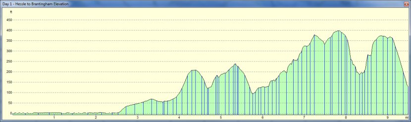
Elevation profile
A poor start for me, travelling to Brantingham to meet Jill, I took a wrong turn and then couldn’t find my way into the village. This didn’t bode very well for my navigational skills as I was only 20 miles from home. Fortunately it was a nice sunny day and I found Jill, and her labrador, Maizee, patiently waiting by the village pond, where we were to leave a car. Making sure we left a change of clothing in that car, we bundled Maizee and my whippet, Ruby, into the other car and set off for the start of the Wolds Way at Hessle.
The Humber Bridge with whippet, Ruby, on the foreshore
The obelisk marking the start of the Wolds Way
At Hessle there was plenty of public car parking and we were able to leave the car in the shade for our return. The start of the route is marked by an obelisk carved with an acorn, the National Trail emblem, and the names of some of the villages on the route. Very soon we were passing under the majestic Humber Bridge and on to the track along the Humber foreshore. This is also a part of the Trans-Pennine route and we met a couple of cyclists and another walker.
The Humber Estuary is formed by the confluence of the River Ouse and the River Trent and separates East Yorkshire from Lincolnshire. When I was young Lincolnshire was virtually a foreign land to the people of East Yorkshire, accessible only by ferryboat or by what was then a long car drive to cross the Ouse and the Trent rivers.
With the railway on our right and the estuary on our left we followed the pleasant trail to North Ferriby, where the Wolds Way then goes onto the foreshore itself. This means that this section can be impassable at high tide. There is an alternative route through the village but this entails walking through residential roads rather than the lovely shady walk of almost a mile through Long Plantation. It used to be possible to walk along the high river bank, Jill remembers often cycling along the bank as a child, but now the bank has been claimed by some of the occupants of the nearby houses and incorporated into their gardens.
We were fortunate and the tide was on the ebb leaving us just enough space to navigate the stony foreshore. As the day was beginning to warm up we enjoyed the walk up through the wooded Long Plantation, to the crossing of the A63. As our guide books* were not sufficiently up to date to show where we could cross the busy new road layout of the A63 we were a little concerned that we may have an unwelcome detour. We need not have worried however as the way had been signed across the bridge and the sliproads, one of the sliproads having a pedestrian operated traffic light.
Continuing northwards through Terrace Plantation we began the first gentle climb up from our sea level start.
St Helen’s Church, Welton
The Green Dragon, where Dick Turpin was arrested.
On reaching the pretty village of Welton we found a handy seat to have our lunch and the dogs enjoyed a drink from the brook beside St Helen’s Church. Welton is the village best associated with the highwayman, Dick Turpin. Living in the village under the guise of John Palmer, horse dealer, Turpin was arrested at the Green Dragon public house, in Cowgate, and taken to be tried and hung at York.
On leaving the village we met our first true dale of the Wolds, Welton Dale. A pretty peaceful dale, with woods to the left of us and open grassy pasture to our right we felt that were were now getting a little taster of the dales of the Yorkshire Wolds which we both love so much.
Walking along field edges and bridleways we eventually reached the highest point of todays walk at 143m (470ft) above our sea level start, and begin the descent down Spout Hill towards Brantingham village. We turn however just before the village to take the Wolds Way path across sheep pasture towards the church which is located just outside of the village at the beginning of the next dale. This lane near the church will be a suitable starting point for our next days walk so we then turned back towards the village and our car, feeling happy that we have had such a lovely beginning to our journey through the Wolds of East Yorkshire.
* The 2007 edition of the “Yorkshire Wolds Way” shows the new route crossing the A63